Complete Guide to Delhi Metro Routes: Lines, Stations & Interchanges
The Delhi Metro has transformed the landscape of public transportation in India's capital region, creating an intricate network of routes that connect the bustling metropolis. With its color-coded lines weaving through the city like arteries, the Delhi Metro has become the lifeline for millions of daily commuters. In this comprehensive guide, we'll explore the entire route of Delhi Metro, covering all lines, key stations, and interchange points to help you navigate this world-class transit system with ease.
The Evolution of Delhi Metro Routes
When the Delhi Metro began operations in December 2002, it started with a modest 8.4-kilometer stretch on the Red Line. Fast forward to 2025, and the network has expanded to over 390 kilometers with 285+ stations spread across 11 color-coded lines. This remarkable growth has made the Delhi Metro the largest and busiest metro system in India and one of the most extensive rapid transit systems globally.
The route of Delhi Metro has been strategically planned to connect residential areas, commercial hubs, educational institutions, and tourist attractions. The network now extends beyond Delhi into neighboring cities like Noida, Ghaziabad, Faridabad, Gurugram, and Bahadurgarh, effectively turning it into a regional transit system that serves the entire National Capital Region (NCR).
Understanding Delhi Metro's Color-Coded Lines
The Delhi Metro uses a color-coding system that makes it easier for passengers to identify and navigate different routes. Each line has a distinct color, and the stations along these lines are marked with the corresponding colors on maps and signage. Let's explore each line in detail:
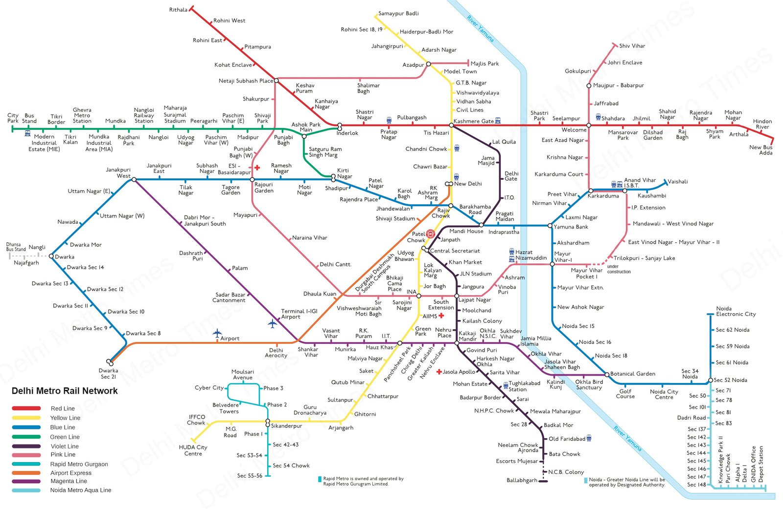
Red Line - Delhi's Original Metro Route
The Red Line holds historical significance as the first operational line of the Delhi Metro. Currently running from Rithala to Shaheed Sthal (New Bus Adda), this 34.4-kilometer route passes through 29 stations. The Red Line connects West Delhi to East Delhi and further extends into Ghaziabad in Uttar Pradesh.
Key stations on the Red Line include Rithala, Netaji Subhash Place, Inderlok (interchange with Green Line), Kashmere Gate (interchange with Yellow and Violet Lines), Welcome (interchange with Pink Line), and Shahdara. The Red Line predominantly runs on an elevated track, allowing passengers to enjoy aerial views of Delhi's landscape.
This route of Delhi Metro serves densely populated residential areas and several commercial districts. It's particularly crucial for commuters traveling between Delhi and Ghaziabad, providing a reliable alternative to road transport.
Yellow Line - The North-South Backbone
The Yellow Line is often considered the backbone of the Delhi Metro network, running from Samaypur Badli in North Delhi to Millennium City Centre in Gurugram. Spanning approximately 49 kilometers with 37 stations, this line connects some of the most important landmarks and busiest areas of the city.
Major stations along the Yellow Line include Samaypur Badli, Delhi University (serving the North Campus), Kashmere Gate (a critical interchange station connecting Red, Yellow, and Violet Lines), New Delhi Railway Station (providing connectivity to one of India's busiest railway stations), Rajiv Chowk (the network's busiest interchange station connecting with the Blue Line), Central Secretariat (interchange with Violet Line), AIIMS, Hauz Khas (interchange with Magenta Line), and finally extending to Gurugram.
The Yellow Line is notable for connecting several educational institutions, government offices, healthcare facilities, and commercial centers. It also provides direct access to historical sites like Chandni Chowk in Old Delhi. For tourists and business travelers, this route of Delhi Metro offers convenient access to various five-star hotels, Connaught Place (one of Delhi's premier shopping districts), and Gurugram's corporate sector.
Blue Line - The Longest Metro Corridor
The Blue Line is the longest route of Delhi Metro, covering approximately 65.1 kilometers with two branches. The main line runs from Dwarka Sector 21 to Noida Electronic City, while a branch line connects Yamuna Bank to Vaishali. Together, these sections serve 59 stations across Delhi, Noida, and Ghaziabad.
This extensive route connects West Delhi to East Delhi and further extends into Noida and Ghaziabad. Key stations include Dwarka Sector 21 (interchange with Airport Express Line), Rajouri Garden (interchange with Pink Line), Rajiv Chowk (interchange with Yellow Line), Mandi House (interchange with Violet Line), Yamuna Bank (where the line splits towards Noida and Vaishali), Akshardham (near the famous Akshardham Temple), Noida Sector 18 (serving one of Noida's premier shopping districts), and Noida Electronic City.
The Blue Line is heavily utilized by professionals working in Noida's IT sector and residents of West Delhi. The route serves several residential neighborhoods, shopping malls, business districts, and recreational facilities, making it one of the busiest lines in the network.
Green Line - Connecting West Delhi to Haryana
The Green Line connects Inderlok in Delhi to City Park in Bahadurgarh, Haryana. With the addition of the branch line from Kirti Nagar to Ashok Park Main, the total length of this route is approximately 29.6 kilometers serving 24 stations.
Key stations on the Green Line include Inderlok (interchange with Red Line), Ashok Park Main (where the branch line towards Kirti Nagar begins), Kirti Nagar (interchange with Blue Line), Punjabi Bagh (serving a major residential and commercial area), Nangloi, Mundka, and City Park.
This route of Delhi Metro serves the western and northwestern parts of Delhi, which were previously underserved by public transportation. It has significantly improved connectivity for residents of areas like Mundka, Nangloi, and Punjabi Bagh, while also providing a direct metro connection to Bahadurgarh in Haryana.
Violet Line - Connecting Heritage to Modernity
The Violet Line runs from Kashmere Gate to Raja Nahar Singh (Ballabhgarh) in Faridabad, covering approximately 46.6 kilometers with 34 stations. This route connects Old Delhi to the satellite city of Faridabad in Haryana.
Important stations on this line include Kashmere Gate (interchange with Red and Yellow Lines), Mandi House (interchange with Blue Line), Central Secretariat (interchange with Yellow Line), ITO (serving government and media offices), Lajpat Nagar (interchange with Pink Line and a popular shopping district), Kalkaji Mandir (interchange with Magenta Line), and key stations in Faridabad.
The Violet Line is significant for connecting South Delhi to Faridabad, serving several residential colonies, commercial areas, and government institutions along the way. This route of Delhi Metro has reduced travel time between Delhi and Faridabad from over an hour by road to approximately 45 minutes.
Pink Line - The Ring Corridor
Often called the "Ring Corridor," the Pink Line forms a nearly complete circle around central Delhi. Running from Majlis Park to Shiv Vihar, this 58.4-kilometer route serves 38 stations and intersects with almost all other lines of the network, making it crucial for interchange purposes.
Key stations on the Pink Line include Majlis Park, Azadpur (interchange with Yellow Line), Netaji Subhash Place (interchange with Red Line), Rajouri Garden (interchange with Blue Line), Dilli Hati INA (interchange with Yellow Line), Lajpat Nagar (interchange with Violet Line), Mayur Vihar Phase I (interchange with Blue Line), Anand Vihar (interchange with Blue Line and railway station), Welcome (interchange with Red Line), and Shiv Vihar.
The Pink Line is designed to reduce travel time between East, North, South, and West Delhi by providing direct connectivity without having to go through central Delhi. This route of Delhi Metro serves several educational institutions, hospitals, markets, and residential areas previously not connected by the metro network.
Magenta Line - Connecting South Delhi to Noida
The Magenta Line runs from Janakpuri West to Botanical Garden, spanning approximately 38.2 kilometers with 25 stations. This line provides critical connectivity between West Delhi, South Delhi, and Noida.
Major stations on this route include Janakpuri West (interchange with Blue Line), Terminal 1 IGI Airport (serving the domestic terminal of Delhi's airport), Hauz Khas (interchange with Yellow Line), Kalkaji Mandir (interchange with Violet Line), Okhla Bird Sanctuary, and Botanical Garden (interchange with Blue Line and India's first interchange station between two metro corridors).
The Magenta Line has significantly reduced travel time between Noida and South Delhi, previously a time-consuming journey by road. It also provides convenient access to educational institutions like IIT Delhi and Jamia Millia Islamia University. This route of Delhi Metro has been designed with several technological advancements, including driverless train operations.
Grey Line - Delhi's Smallest Metro Corridor
The Grey Line is the smallest route of Delhi Metro, running from Dwarka to Dhansa Bus Stand. This 5.2-kilometer line serves 4 stations and acts as a feeder service to the Blue Line at Dwarka.
The stations on this line are Dwarka (interchange with Blue Line), Nangli, Najafgarh, and Dhansa Bus Stand. Despite its short length, the Grey Line is significant for connecting the previously underserved rural areas of Najafgarh and its surrounding regions to the main metro network.
This line uses smaller train sets compared to other lines due to lower passenger demand but maintains the same quality of service and frequency. The Grey Line has improved access to central Delhi for residents of these outer areas, reducing their commute time significantly.
Orange Line - The Airport Express
The Airport Express Line (Orange Line) runs from New Delhi Railway Station to Dwarka Sector 21, spanning 22.7 kilometers with 6 stations. This high-speed line is designed specifically to connect Delhi's city center to Indira Gandhi International Airport.
The stations on this line include New Delhi (interchange with Yellow Line and railway station), Shivaji Stadium, Dhaula Kuan (interchange with Pink Line), Delhi Aerocity (serving several hotels), IGI Airport (integrated with both Terminal 3 and Terminal 2), and Dwarka Sector 21 (interchange with Blue Line).
The Airport Express Line offers several unique features compared to other routes of Delhi Metro. It operates at higher speeds (up to 90 km/h), has comfortable seating arrangements, dedicated luggage space, and in-train WiFi. This line has significantly improved accessibility to the airport for both travelers and airport staff, reducing the travel time from New Delhi Railway Station to the airport to just 18 minutes.
Critical Interchange Stations on Delhi Metro Routes
Interchange stations form the backbone of the Delhi Metro network, allowing passengers to transfer between different lines. Understanding these hubs is crucial for efficient journey planning. Here are the most important interchange points across the route of Delhi Metro:
| Interchange Station | Lines Connected | Significance |
|---|---|---|
| Rajiv Chowk | Blue Line ↔ Yellow Line | The busiest station in the network, located at Connaught Place in central Delhi |
| Kashmere Gate | Red Line ↔ Yellow Line ↔ Violet Line | A major transport hub connecting with ISBT, serving as a triple interchange |
| Central Secretariat | Yellow Line ↔ Violet Line | Connects government districts and provides access to Raisina Hill |
| Mandi House | Blue Line ↔ Violet Line | Cultural hub connecting several theaters and art centers |
| Inderlok | Red Line ↔ Green Line | Major interchange for commuters traveling to west Delhi |
| Welcome | Red Line ↔ Pink Line | Important interchange in East Delhi |
| Hauz Khas | Yellow Line ↔ Magenta Line | Connects South Delhi to Noida and IGI Airport Terminal 1 |
| Botanical Garden | Blue Line ↔ Magenta Line | First interchange station in Noida, reduces travel time between Noida and South Delhi |
Planning Your Journey: Making the Most of Delhi Metro Routes
Navigating the extensive route of Delhi Metro might seem daunting for first-time users, but with some planning and understanding, it can be a smooth experience. Here are some tips for planning your journey:
Understanding the Delhi Metro Route Map
The Delhi Metro route map is available at all stations, inside trains, and on the official website and mobile app. The map uses color-coded lines to represent different routes and interchange stations are marked with special symbols. Familiarize yourself with the map before starting your journey, especially if you need to switch lines.
Choosing the Optimal Route
When traveling between two points, there might be multiple route options. Consider factors like:
- Number of interchanges (fewer interchanges usually mean a more convenient journey)
- Total distance and estimated travel time
- Crowding on different lines (some lines and stations are more crowded during peak hours)
- Walking distance during interchanges (some interchange stations require longer walks between platforms)
The Delhi Metro Rail Corporation (DMRC) official app provides route suggestions with estimated time and fare information, making it easier to choose the optimal route.
Peak Hours and Off-Peak Travel
The Delhi Metro experiences heavy crowding during peak hours (8:30 AM - 10:30 AM and 5:00 PM - 8:00 PM on weekdays). If possible, plan your journey outside these hours for a more comfortable experience. Some routes of Delhi Metro, particularly the Yellow and Blue Lines, can get extremely crowded during peak times.
Smart Card vs. Token
For frequent travelers, the Delhi Metro Smart Card offers convenience and a 10% discount on fares. It also saves time as you don't need to queue for tokens for each journey. For occasional travelers or tourists, single journey tokens work well but require purchasing before each trip.
Exploring Delhi Through Its Metro Routes
The route of Delhi Metro doesn't just provide transportation—it offers a unique way to explore the city. Here are some notable destinations easily accessible via the Delhi Metro:
Historical and Cultural Sites
- Red Fort and Jama Masjid: Accessible from Chandni Chowk station (Yellow Line)
- Humayun's Tomb: Close to Jangpura station (Violet Line)
- Qutub Minar: Accessible from Qutub Minar station (Yellow Line)
- Lotus Temple: A short walk from Kalkaji Mandir station (Violet and Magenta Lines)
- Akshardham Temple: Adjacent to Akshardham station (Blue Line)
- India Gate and Rashtrapati Bhavan: Accessible from Central Secretariat station (Yellow and Violet Lines)
Shopping Destinations
- Connaught Place: Rajiv Chowk station (Yellow and Blue Lines)
- Chandni Chowk markets: Chandni Chowk station (Yellow Line)
- Sarojini Nagar Market: INA station (Yellow and Pink Lines)
- Lajpat Nagar Market: Lajpat Nagar station (Violet and Pink Lines)
- DLF Mall of India, Noida: Noida Sector 18 station (Blue Line)
- Select Citywalk, Saket: Malviya Nagar station (Yellow Line)
Future Expansions: The Growing Route of Delhi Metro
The Delhi Metro network continues to expand with new lines and extensions planned for the future. Phase IV of Delhi Metro expansion will add three new lines and extend three existing lines, adding over 100 kilometers to the network. These expansions will connect more outer areas of Delhi and further integrate neighboring cities into the metro network.
Upcoming routes include the extension of the Magenta Line to Janakpuri West, new connectivity to Aerocity from South Delhi, and better coverage in areas like Narela and Bawana. These expansions will further cement Delhi Metro's position as one of the most comprehensive urban transit systems globally.
Conclusion: The Lifeline of Delhi
The route of Delhi Metro has fundamentally transformed how people move across the National Capital Region. What started as a modest project has evolved into a world-class transit system that serves as a model for other Indian cities. With its extensive network covering over 390 kilometers, the Delhi Metro connects distant corners of the metropolis, reducing travel time, easing road congestion, and lowering pollution levels.
Beyond transportation, the Delhi Metro represents modern India's capability to execute large-scale infrastructure projects efficiently. Its clean stations, punctual service, and accessibility features have set new standards for public transportation in the country. Whether you're a daily commuter, a tourist exploring the city, or a business traveler rushing between meetings, the Delhi Metro offers a reliable, affordable, and comfortable way to navigate the sprawling capital region.
As Delhi continues to grow and evolve, its metro system grows with it, constantly expanding its reach to serve more communities and connect more destinations. The route of Delhi Metro isn't just a transit network—it's the pulsing lifeline that keeps India's capital moving forward.
Plan Your Delhi Metro Journey Now
Explore the full Delhi Metro network, calculate fares between stations, and find the quickest route to your destination.
Use Fare Calculator View Metro Map